
April 16, Assateague Island, Pine Point: It’s very cold this morning. I have been cold all night. I’m wearing long johns and two polartec sweaters. I have a knit hat on my head. I’m in a 150 sleeping bag. I’m still cold. The neighbor has a thermometer on his table that reads 350. My car thermometer reads 340. This weather is 100 colder than the lowest we had planned for. It’s colder here than at home!
We crawl out and make our way to the bathhouse. I brush my teeth, drag a comb through what hair I have left and shave. Then we quickly knock down our tent and fill our water bags for the Assateague trip. Soon, we’re heading off to find warm coffee and breakfast.
After breakfast, we head for the National Seashore Visitor’s Center to once more inquire about the maps our guide book said would be available there. They are not available any longer, and no one presently working at the center has any memory of them. We are directed to a fishing marina and West Marine as possible sources.
After a short ride we spot a West Marine store and secure two waterproof maps at what seems like an exorbitant price. We’re in no position to argue. These are navigation maps. The scale is such that the coastline is not shown in great detail. It is too shallow for general navigation by powerboats anyway. That means that any navigation aids that could be used as landmarks are not available in the area we are traveling. The charts do have GPS scales at the sides that we will use in conjunction with our small GPS units to approximate our position on the water.
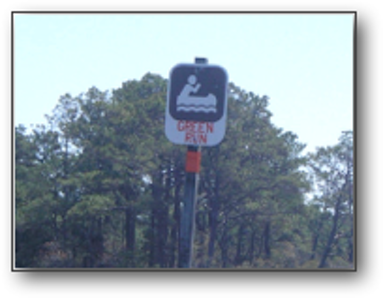
Back at Assateague Island, we check in at the ranger station to reserve our back country campsites for the next few nights. Bruce, who hasn’t paddled since last November, wants to go half way to Pope Bay campsite on the first day, then on to Pope Bay on day two, and finally part of the way back again on day three before returning to our launch point at Ferry Landing. I would rather go the whole distance to Pope, stay two days, then return half way on day three before returning to Ferry Landing. Pope Bay is the furthest campsite, more than 12 miles from Ferry Landing through some convoluted passages between low-lying grassy islands. It’s difficult to find. The question was settled when Pope, which has only two campsites, was not available till the next day. We agreed to stay on Pine Point for day one, Pope Bay for day two and back to Pine for day three, before returning to Ferry Landing on day four. Pine Point is the second site on the trail, 3 miles past Tingles Island, about a 5 mile paddle altogether. The next site, Green Run, is about 4.5 miles beyond Pine. From Green, it is a short but convoluted 2.5 miles to Pope.
Assateague Island and our route.
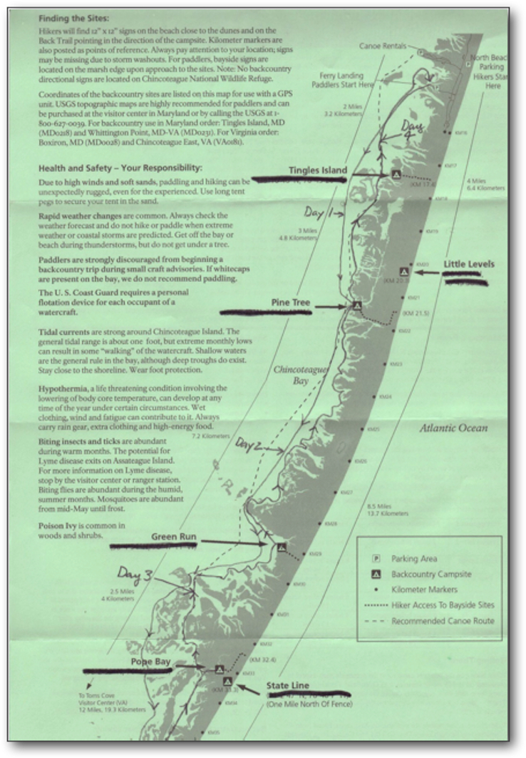
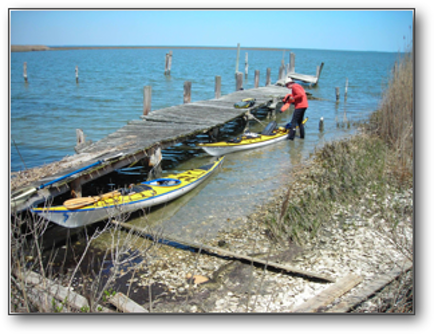
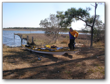
We arrived at Ferry Landing just after 11:00 am. We began the process of loading the boats for a four-day trip. As we had originally planned for five or even six days, we tried to eliminate a few unnecessary items from our gear. In the process, each of us left important pieces of gear behind. (Bruce, his flashlight and headlamp; Me, all of the gear for washing and sanitizing our dishes and cooking gear.) We were on the water by noon, the air temperature was in the low 50’s, there was a NE wind blowing at about 12 mph, and the water temperature hovered near 500. Bruce wore his dry suit. This time I wore my wet suit and my paddling jacket. Folks who seem to know about these things say that a water temperature of 500 is the dividing line between recommending the use of a dry suite (500 or lower) and wearing a wet suite (500 to 600 degrees).
The water is very shallow in close to shore, and we were at low tide (the tidal range is only about a foot here). Often our paddle blades would scrape the bottom on even low angle strokes. Shallow water slows a boat down, as the bow wave is thrust down causing drag along the bottom. It often feels like paddling in Jello. A little more water under the bow and the boat takes off. The difference in the way the boat feels is dramatic.
We paddled several miles off shore, where we could still often see the bottom. The trip itself was very pleasant. It felt really good to be on the water again, to feel the motion of the boat and the working of those dormant paddling muscles. We made quick time, and by checking our location on the GPS against coordinates we got from the Visitor’s Center and on our maps, we were easily able to locate Pine Point. We arrived at about 3:00 pm to find a canoe at the pullout and a tent close by on the shore. The owner of this gear was no where to be seen.
The landing at Pine Point opens into a large grassy area surrounded by trees, giving good shelter from both wind and sun. It could have easily held many tents. We assumed that this was the camping area and set up camp at the back of the clearing. After a while, the other camper, a lone man, appeared, and without saying much, packed up his things, loaded his canoe and headed out for Pope Bay. We took a hike before dinner and somehow missed the real camping area that lies in a heavy woods, hundreds of yards from the landing
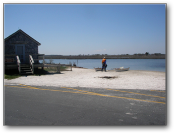
The beach side of the island has high dunes and constantly breaking surf that can be heard from the bayside. In the quiet of the night, it sounds for all the world like the sound of jets taking off, one after the other, from an airport hotel room. The beach was beautiful, but in a sense, boring. It looked the same, mile after mile, with few distinguishing features.
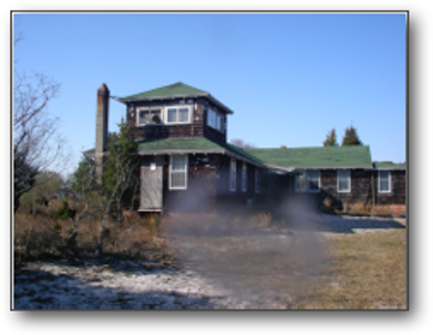
On the way back to camp, we saw a trail leading south over a bridge. We followed it to the site of an abandoned building. When the government declared Assateague a national seashore in the 1960’s, it reclaimed the few pieces of developed land on the island, marked them as government property and left them as they were.
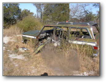
This site had a wonderful collection of rusting vintage vehicles, including a Willys Corporation Jeep (Yes, Willys made the Jeep before American Motors bought it and then sold it to Chrysler) and an International Harvester pick-up with a car body (the first SUV). There was also an early ATV. It was made of fiberglass with a rear engine in an articulated body. There was also a herd of wild ponies grazing in the area. We spent some time observing and photographing them before heading back to camp.
On our way back we discovered the “official” campsite. It consisted of some five sites scattered over a large area in the woods. We discussed moving to this area, but it was dinner time and we needed to get our food cooked and cleaned up before dark, so we decided to stay where we were.
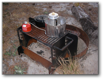
I was responsible for planning and cooking dinner. The meal tonight was three-cheese tortellini mixed with sautéed onions, garlic and bacon, and topped with a balsamic vinaigrette dressing. Desert was baked bananas, drizzled with chocolate syrup. I thought it was quite tasty! (Thanks to Scott Locorini for the recipes.)
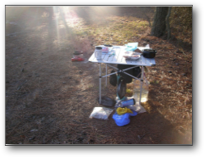
The food was cooked on two different MSR stoves, one a liquid gas stove, the other a butane/propane canister stove. We practice leave-no-trace camping. The area around the stoves was cleared of duff, the stoves were placed on metal pads and surrounded by wind shields. The area was restored to its natural state when we left. All garbage was double bagged to be hauled away.
By the time we finished dinner and clean up, the sun was going down and it was beginning to cool off. Bruce went to use the port-a-john where he spotted a regulation that said all camping must be within fifty feet of a fire ring. Once more, we discussed what to do, but decided that moving camp in the dark was not a cool idea. We missed the designated campsite in the first place because another camper was already camped by the water and because we never expected the camping area to be so far removed from the launch point. Then, we didn’t discover the regulation about distances from the fire ring until Bruce’s sundown call of nature when he found the regulation taped to the inside of the port-a-john door. We elected to stay put and face the consequences if necessary.

April 17, Assateague Island, On to Pope Bay: It was a comfortable night, warmer than any so far. We did the usual coffee and fortified oatmeal breakfast. Then it was knock down camp, pack up the boats and head out. The distance to Pope Bay campsite was about 8 miles, but the path wound between and behind a number of low islands, making it easy to get off course. The wind was light at 5 to 10 mph from the NE, giving us a gentle push. We were moving along at about 4.0 mph.
We decided to find Green Run Campsite. We again used a combination of our charts, GPS units and the waypoints provided by the NPS to zero in on the Green Run location. It wasn’t where it should have been, or so we thought, so we moved on.
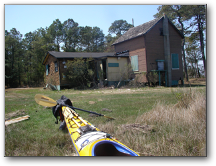
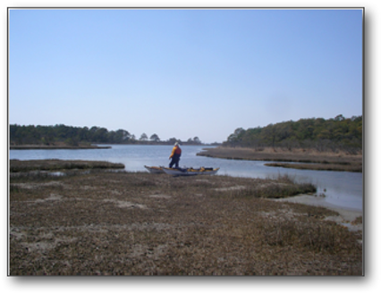
We were getting hungry. It was way past lunch. Finally, we stopped at an abandoned house on a treeless island where we found a bench, spread out our lunch and relaxed for a while. The house consisted of three manufactured home modules (read trailers), nestled side by side and connected internally. They were all perched on pilings and looked like they had been added one at a time over some years, as each unit sat at a different height. An effort had been made to unite them into a whole by re-siding all the units as one house. Sitting there, I wondered about the people whose sweat and dreams had been tied up in this place? I wondered what had happened to them and this island? What they were doing now?
Consulting our charts once again, we picked what looked like the most likely route and compass course through the islands and into Pope Bay. Back in the boats, we set a fast pace, knowing that we were only a few miles away from our campsite. As two miles turned into four and then six, we knew we had missed the route into the bay. As I was about to turn back to retrace our steps, Bruce found the southern entrance to the bay. Now it was a two plus mile paddle north to the Pope Bay campsite. Our 8-mile paddle had turned into 15.4 miles and almost 5 hours on the water!

The Pope Bay Campsite was the best we had seen. There are only two sites at this spot, both near the water. Sites that are far removed from the launch point are hard on kayakers. Because of our need to fit everything through small hatches, we carry many small bags of gear and supplies. Unless we carry two or three large net bags to put all of this stuff into, we make many trips back and forth to our boats to retrieve gear. At Pope Bay our boats were close by. This was the only site with this advantage on Assateague Island.
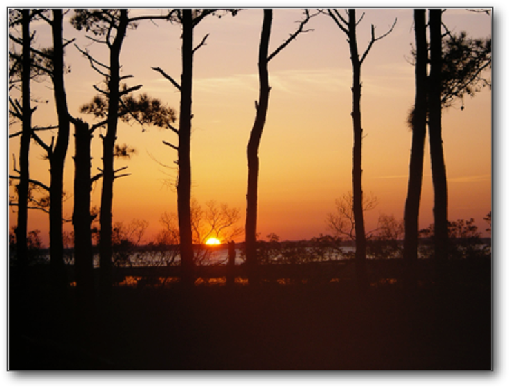
We shared the site at Pope with two fellows from Long Island, Ken Doxsey and Peter Staley. They were great guys, eager to share any information they had on the island, especially navigation information. They were also generous in the sharing of a good bottle of wine! Dinner tonight was pepperoni pizza. It tasted pretty good considering that it was made in a camp stove oven. We turned in after watching a glorious sundown.
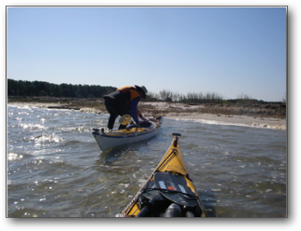
April 18, Assateague Island, Back to Pine Island Campsite: I guess I’m hard to please. It was almost too warm last night. I finally got the ratio of spoons full of coffee to water right. The coffee was good. Pete and Ken joined us for a while. Pete had some coffee while we finished our oatmeal. Bruce gathered more navigation data while I began breaking down the cooking gear and packing up my sleeping bag and pad. Pete and Ken were staying at Pope for several days. Today they would head south to Chincoteague Island to do some exploring. While I was busy packing my boat, Bruce got involved in getting them launched. I didn’t see what happened, but all of a sudden, Pete’s boat was on its side, he was in the water and Bruce was apologizing profusely.
Soon we were packed and underway. It always feels good to be back on the water. We headed out heading generally north, following the shoreline. The wind had switched from NE to SW, so we again had the wind at our backs. It didn’t take long to see our error of the day before. From the abandoned house, we should have paddled due south, not southwest to find Pope Bay. This would have taken us deeper into the bay and closer to the actual shoreline. We had paddled along the outer side of a secondary group of islands. Looking across them to features on the actual shore, it was impossible to see that there was more open water in between. Next time will be easier.
Sticking to the shore, we again tried to find the Green Run campsite. On the trip down yesterday I paddled along a bay that had signs warning paddlers to keep out, as it was a protected area. I had a hunch that Green Run was somewhere near this spot, and my GPS readings confirmed this notion. This time I paddled along the line of sight toward another abandoned building. The restriction signs seemed to leave a narrow channel at the South side of the bay, leading past the building. Just past the building was a sign for the Green Run campsite. The trail in was poorly marked and very misleading, as the restriction signs seemed to indicate that the entire bay was off limits.
We couldn’t land near the campsite sign because there was only a narrow shelf of shallow water there. We paddled back toward the building and found a wider shelf that allowed us to get out and pull the boats ashore. There was nothing in the immediate area that looked at all like a campsite beyond a forlorn port-a-john parked under a tree. Remembering the Pine Point experience, I followed a road for some distance into the woods and there found a three site open camping area, surrounded by trees.
I went back to the boat, grabbed the lunch bag and headed back to the campsite, where Bruce was trying to take a nap on a picnic table. I say trying because he was busier slapping mosquitoes than napping. Lunch was more of a snack than a meal. I drank a lot of water, then we headed back to the boat to resume our trip.
We both enjoy paddling close to shore because we see so many interesting things. Because it was less than five miles to Pine, we poked along, investigating every little bay and indentation. Soon the day began to get away from us. It was four o’clock, we were not yet at camp, and we needed to set up camp and prepare a meal before dark. Bruce showed no indication that he wanted to move any faster. When the GPS read that we were less than a mile from camp, Bruce poked into another little inlet. I stopped paddling to wait for him. I sat quietly for some time, just enjoying the warmth and the slight breeze. When I looked around to check on him, Bruce was nowhere to be seen.
In this shallow water and wearing a dry suite, I knew he was all right. Still, I needed to check “just in case.” I followed the inlet back to a bridge where the inlet passed under and turned south. No sign of Bruce. Paddling faster, I flew up the other side until I reached the bay. Again, no Bruce. Now paddling faster along the shore, I start to wonder what my next steps were if I still couldn’t locate him. Finally I saw him ahead, paddling slowly from behind another low island. I was hot and sweating. He was oblivious.
As we pulled closer to Pine, we could see many boats pulled up on shore, essentially blocking the whole launch area. I counted two sailboats, at least four canoes and four kayaks. There was a loud Bocce game being played on the open area where we had camped previously. We each got out of our boats and found an open space to pull them ashore. I was not in a friendly mood at that point, so I busied myself gathering my tent and sleeping bag and heading up toward the camping area. Bruce stayed behind to talk to the folks playing Bocce.
As I said earlier, it’s quite a hike from the launch area to the campsite. When I got there, there were tents everywhere. I began to look for an open site. The three closest sites were occupied by the Bocce players and their friends. There must have been ten to fifteen tents in this area. Further on was another occupied site, and finally, a good quarter mile from the launch point was the last site, also taken. I asked a woman relaxing in the fourth site if there were any more sites around. She didn’t know. I searched for a while and found nothing, so I returned to the launch point carrying all my gear.
Bruce asked why I was still carrying all my stuff. I answered with some annoyance that someone was obviously in a site without a permit. The Bocce players assured us that they had three permits and had taken three sites. It was after five o’clock, I was tired, hungry and wanted to get on with setting up camp. Bruce went to the forested site, took a look and said we should camp where we had camped two days earlier. I protested because I didn’t want to be out of compliance with the regulations. However, Bruce insisted that we were not the NPS police and it was not our job to find who was there without a permit. He said that maybe the NPS had issued too many permits. In either case, wherever we camped that night, we would be out of compliance.
We set up camp in the lower area again. It was nearly sundown by the time camp was set, dinner was served and clean-up begun. Bruce asked if I wanted to walk over to the beach. I declined. I was tired, I was still cleaning up from dinner and my boat needed attention before dark. My work was done just as the sun set. I tried to call Lisa, but only got the answering machine, so I left a message and turned off the phone to preserve what was left of the battery. I crawled in to the tent before Bruce returned to do some journaling and soon was asleep.
April 19, Assateague Island, We Return to Ferry Landing: It was another warm night. I was up shortly after six o’clock. The coffee was soon perking on the stove and breakfast was laid out. Our breakfasts consisted of a base of instant oatmeal, with a smorgasbord of additions: raisins, walnuts, dried fruit, granola, brown sugar and powdered milk. It was hardy and quick, and seemed to easily hold off hunger till lunch.
Bruce cleaned up the dishes while I packed my sleeping bag and pad. Then I broke down the kitchen set up. This includes two MSR stoves, a small percolator, two cook pots, a camp oven and an aluminum table that packs into a 4 by 6 by 30 inch bag that I strap to my back deck. We were packed and ready for the water shortly after 8:00 am. That’s when I couldn’t find my camera.
We had had conversations with several of the Bocce player’s group last evening and this morning. We discovered that one member of the group was an editor for Paddler magazine, the ACA’s official publication. His friend, Tom Wilhelm, had also lost a camera, though Tom thought his camera had gone overboard in a floating camera bag sometime the day before.
I pulled everything out of my day hatch, then started on the rear hatch, emptying my dry bags of clothing. At this point, I guessed it had gotten packed up with either my sleeping bag or tent. I often stored the camera in a side pocket of the tent. Time was passing. I didn’t want to unpack anything more looking for the camera. Tom and I exchanged email addresses in case either of us should turn up the other’s camera. At about 8:40 am, we shoved off without the camera in hand.
The paddle back was easy and pleasant. Light winds from the SW pushed us quietly along. We were at about half-tide, which meant we had a few more inches of water under our boats than on the trip out. We stayed fairly close to shore, stopping here and there to investigate something or watch the wild ponies feeding on the low islands. At one point we heard some thrashing in the water and looked to find a small herd of ponies wading from one low island to another to continue their foraging for food.
Finding the way into Ferry Landing was more problematic than we expected. We could easily see the boathouse at Ferry Landing, but the way was blocked by several ranks of these same low islands. Which way should we go? North or south? We tried several routes only to end up in a dead end. Finally, we saw a sailboat leave the landing and head north, emerging around a point of land close to shore. Retracing its course, we were soon at Ferry Landing, ready to unload our boats for the trip home. It was about 10:45 a.m.
Resources:
Assateague Island National Seashore
Assateague Island National Seashore Visitors Services
