Why This Report: I outlined a paddling trip on the Indian River Lagoon for the organization, Paddle Florida, Inc. based on a trip I took almost ten years ago. (A description of the trip follows this introduction.) I have paddled with Paddle Florida, on two or more trips each year for almost ten years. These adventures have taken me all over the state into remote paddling areas that most folks will never know about or see.
Last winter I realized that there had never been a Paddle Florida trip on the Treasure Coast where I live. I found that in most people’s mind, Florida’s East coast is all high rises and heavy development. But that’s just not so, especially in Indian River County. So I proposed a route similar to the one in the trip report below, except that the camping sites could not be on islands. We needed land sites in order to accommodate our equipment trucks, porta-Johns, and food concessionaires. This is the route I proposed and we agreed on:
Our Proposed Route:
- Day 1: Arrive at Fort Pierce Inlet State Park, stay overnight
- Day 2: Launch from Fort Pierce Inlet SP, paddle to Round Island Riverside County Park, stay overnight
- Day 3: Launch from Round Island Riverside County Park, Paddle to The Environmental Learning Center (ELC), stay overnight
- Day 4: Stay at the ELC for a second night
- Day 5: Launch from the ELC, paddle to the Sebastian Inlet State Park Marina, stay overnight
- Day 6: Launch from the Marina, paddle across the Lagoon to the St. Sebastian River and Donald MacDonald County Park, stay overnight
- Day 7: Launch from Donald MacDonald and paddle upstream on the St. Sebastian River to the takeout off Water Valiet Road for lunch and a return to vehicles left at Ft. Pierce SP.
The trip launches on December 2, 2020. If you think you might be interested, go to www.paddleflorida.org. Hope to see you there!

The Trip Report, February 2011
On the Florida Saltwater Circumnavigation Paddling Trail: Segment 21
Bruce left the hostile northern winter weather behind early on a cold February morning and arrived at my home in Sebastian in the late afternoon of the next day. That must have been a record of some kind! When I jokingly asked him what had taken him so long, he complained about the three lanes of stop and go traffic in Daytona that was trying to get into the Daytona 500 auto race. After catching up on the news and gossip from home, we set about readying our gear for tomorrow's launch.
Day 1: We arrived at the north causeway boat launch near the Fort Pierce Inlet about 10:00 AM, just at high tide. This launch area features a triple wide, paved boat launching area at its western end. This is not a kayak friendly launch point and should only be used as a backup.
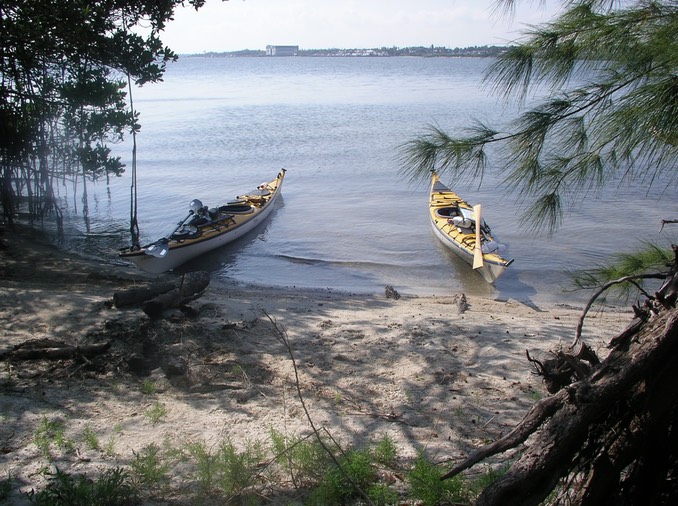
Tucked out of the way along the northeastern end of the parking lot is a small opening in the trees leading to a beach perfect for staging and launching kayaks. The sand is firm, not muddy, and the water deep enough to easily launch a loaded expedition boat, as long as it is not past half-tide, heading for low. Lisa was with us. She would shuttle the car back home until the end of our trip when we would call her with a take-out location. Our plan was to end our trip at Goode Park on Turkey Creek in Palm Bay in four days.
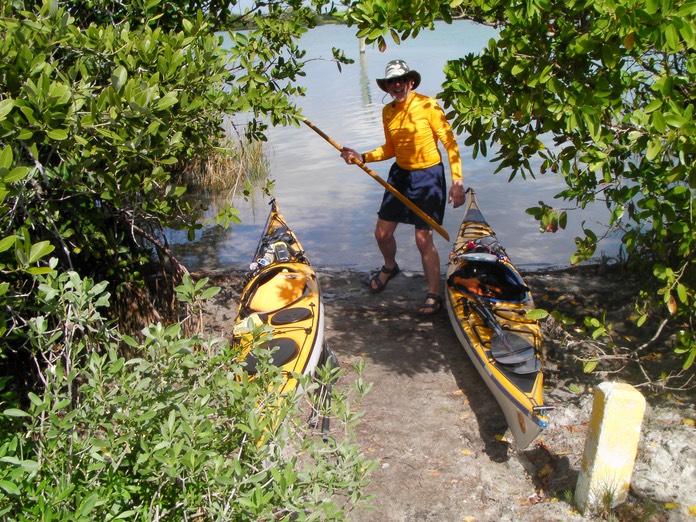
It took about 50 minutes to load the boats, take the ceremonial photos and say our good bye to Lisa who would use her freedom to do some shopping for our new home in Sebastian. The boats were heavy with gear, especially from the two-day load of water we carried. The rule of thumb guiding water consumption is one gallon of water per person per day. We had all of that and more, as we were unsure of just where we could get a fresh supply. We dragged our boats over some shallow spots to get to water deep enough to float our bloated boats with our added weight. Then we were off.
We headed northwest toward the Intra Coastal Waterway (lCW) and the first of the spoil islands. We stayed behind (east of) the spoil islands, avoiding boat traffic on the ICW. It was a beautiful day - blue skies, white clouds and lots of sunshine. As is typical on the Lagoon, the wind began to build as we passed the early morning calm and moved toward noon. Today it came from the south, creating a following sea of one to two feet. The wind built to 15-18 MPH. The back end of my boat kept wanting to slue around. I concluded that I had placed too much weight in the front hatch. But I would have to wait to correct it later.
We stopped briefly at SL8, a "restored" island (SL8 = Saint Lucy County Spoil Island #8. Spoil Islands are named for the county in which they are found: SL = Saint Lucy County, IR = Indian River County and BC = Brevard County. Islands within each county are numbered consecutively, with the northern most island in each county being designated #1”). A restored island is one where the non-native and invasive flora has been removed and replaced with native species. The island really looked like it had been scalped, compared with others. It appeared that the work had been recently completed. It would be a while before the island regained a natural look.
As we paddled north the wind continued to build. All the islands we were passing now were labeled "conservation" islands, which meant we were not supposed to go ashore. We couldn't have anyway as these islands were ringed with mangroves, without any open beaches to land on. As we approached the Barber Street Bridge in Vero Beach, Bruce decided we had to have lunch. He nosed his boat onto the lea side of a low oyster bar in the full force of the wind and got out. There wasn't a tree or even a blade of grass to blunt the force of a wind that felt as strong as the wind we had once encountered at Woods Island in Lake Champlain some eighteen months earlier (See this trip report).
Even so, we were both hungry, so we hunkered down and ate. We had brought our own lunches. Mine was apples and cheddar cheese, with some carbohydrate snacks on the side. I love the combination of a bite of a crisp apple followed by a bite of extra sharp cheddar cheese. I would have this every day. Bruce had brought tortillas and small foil packs of flavored tuna, his choice for each day of the trip. This makes a good sandwich and it travels well, but tuna everyday is more than I can handle.
Despite the strong wind and rough seas, we did manage to see quite a bit of wildlife. We identified Bottlenose Dolphins, Osprey, Great Blue Heron, Little Blue Heron, Great Egrets, flocks of Ibis, Brown and white pelicans, King Fishers and Black Buzzards,
As the afternoon grew late, we began looking for Gifford Point (IR28) our proposed campsite for tonight. Gifford Point lies at the northern end of the Vero Narrows, the narrowest section of the Indian River Lagoon. We finally found IR28 and paddled most of the way around it, but could find no access point, let alone an open area for camping. We passed IR 27 and IR 26 with no luck either. IR 25 is a relatively large island with some broken down docks. We stopped briefly, but didn't stay, as it didn't look too inviting. (insert newspaper PDP here)
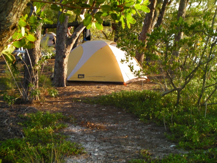
Finally we spotted tiny IR 25A. IR 25A is a little gem of no more than an acre in size. There is a nice beach and an open area under tall trees containing one campsite. There was a broken down picnic table with one end ragged and the other end held up by an old log. A primitive fire ring of stone graced the center of the site. We found a cast off queen size air mattress slung over a fallen tree. Bruce quickly commandeered this, placing it on the ground to act as a staging area for the gear he was pulling out of his boat. As we set up camp we noticed an Osprey nest in one of the big trees just above our camp. Dinner was red beans and rice with sausage.
The wind had dropped off to nothing, so the bugs came out in force at sundown. We stood it as long as we could without bug spray (I hate the sticky, oily stuff, especially before bed when I can't wash), then retreated to out tents. It was hot and muggy. It would be a warm night. I took notes on the day's events, then pulled out my Su Doku for Dummies book , teaching myself how to do those blasted puzzles before turning in.
DATA;
- Trip Odometer: 18.3 miles
- Paddled Today: 18.3 miles
- Maximum Speed: 7.0 MPH
- Time Moving: 4hr, 42min
- Moving Average: 3.9 MPH
- Time Stopped: 31min.
- Overall Average: 3.5MPH
- Location for the Night: of IR 25A
(N 27degrees, 42 minutes, 16.5 seconds,
W 080 degrees, 23 minutes, 38.2 seconds)
Day 2: It was a long night, warm, very pleasant really, but long. Sunset was before 6:30 PM last evening. The bugs drove us into our tents by 7:00 PM. Dawn happened sometime after 6:00 AM with sunrise after 7:00 AM. That means we had spent close to twelve hours in our tents. As I said, it was a long night.
I checked my watch at 4:00 AM, at 5:00 AM, and again at 6:00 AM, finally rolling out of my bag into the semi-darkness of my tent around 6: 15 AM. I busied myself doing the stretches that keep my arthritis at bay and then began to pack up the interior of my tent. With this mostly done, I left my tent to find Bruce and some coffee. It was seven o'clock.
Making good coffee on a paddling trip is somewhat problematic. The gear to make a good cup takes up a lot of room. I've used a five-cup percolator, a French press (including the one that is a part of my Jet Boil stove), a cone filter that makes a single cup and those Folgers tea bag style single cup brewers. They all make a decent cup of coffee (all but the Folgers, that is), but require varying degrees of cleanup that take time and use valuable fresh water. This time I stooped to instant. But not just any instant: I brought Starbucks new instant coffee. It is packaged in small tubes, is ground to a very fine consistency and comes in a variety of roasts. I had tried a cup at home and found it as good as most perked coffee. That proved to be true on this trip too. There was a medium roast Breakfast Blend for me, and an Italian Dark Roast for Bruce.
After coffee and breakfast, I sorted my gear and loaded my boat with more weight at the back this time. I hoped that the boat would balance better that way. We were on the water by 9:00 AM on a rising tide. The wind was light, the sky was Florida Blue, punctuated here and there by puffy white clouds: Just another day in paradise! We were to make a planned stop at the Wabasso Causeway where we would make a bathroom stop and hopefully replenish our water supply. My reconfigured boat was handling much better than it did yesterday.
It was 5.4 miles to the Causeway. We pulled onto a small beach on its south side and went exploring. I stayed near the boats while Bruce made a bathroom run, then he did the same for me. There were lots of people around, so we didn't want to leave the boats unattended (paranoia?). The only source for water that we could find was the faucet in the bathroom sink. It was corroded and nasty looking, so we elected not to refill here. We still had more than a day's supply in our boats.
After a snack and some water we were back in the boats. We passed under the low causeway bridge, then made a sharp right, heading east along the north side of the causeway until we reached the ICW where it passed under the Wabasso Bridge. There was significant boat traffic here, so we waited for a clear passage, then took off at a fast pace paddling side-by-side to cross the ICW as quickly as possible. (I mention this side- by-side paddle because I know that Scott Keller, the leader of the Great Hudson River Paddle who taught us this safety maneuver for crossing a busy boat channel, will be smiling when he reads this.)
Past the bridge, the river began a wide curve to the left behind large mangrove islands. Our easterly course brought us to the eastern shore of the Indian River Lagoon and changed our course to north along the eastern shore. We passed through a lovely, secluded and well protected anchorage with many boats at moorings, and no one around. Soon we were paddling parallel to the fabled Jungle Trail, a remnant of an original Florida road, now a conservation area and part of the Pelican Island National Wildlife Refuge. Pelican Island was the first national wildlife refuge, created by Congress and President Teddy Roosevelt in 1903. The island itself is tiny, but the refuge has grown to encompass much of the land that surrounds it.
It was a lovely paddle in this isolated area. We could have been a hundred miles from any civilization but for the sound of a high altitude jet somewhere above us. We saw many birds here (that's what Pelican Island is all about), but what we really wanted to see were manatee. Or "the elusive manatee" as we began to call the animals we were not seeing.
I was able to spot the only launch spot in the preserve, which lies on the Jungle Trail. It is visible at a distance only because it is surrounded by tll Australian Pines, an invasive species. They are here and nowhere else in the preserve because this one small spot is privately owned. All the other Australian Pines in the preserve have been removed.
Soon Pelican Island itself came into view. Markers warning boaters not to come any closer to the island are set so far out from shore that you can't really see anything. So we passed by the island, continuing along the eastern shore for a while longer, then headed northwest across the lagoon toward the islands, IR6, IR5, and IR4. These islands lie just off the Sebastian shore. We stopped briefly at IR5 for a late lunch break, then continued on to IR3 where we took a minute to examine an old shipwreck there.
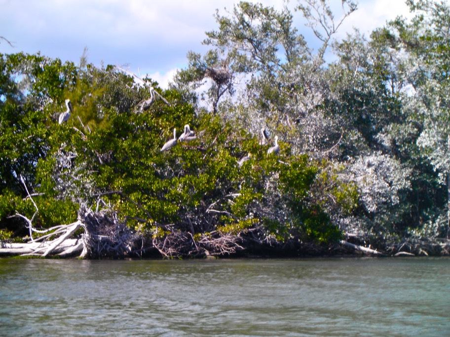
Next came IR2, not officially designated a conservation island, but nobody told the birds that. It is loaded with an impressive variety of large birds including Brown Pelicans, White Pelicans, Osprey, Great Blue and Little Blue Heron, Ibis, Great White Egrets, Black Buzzards and more. The White Pelicans squatted on the sand spit digesting their catch. The Brown Pelicans roosted in the trees, preening and dozing in the afternoon sun, while covering everything below them with "Florida Snow". The Black Buzzards soared above everything, rocking back and forth on their vee-shaped wings as they looked for their next meal. The Osprey's unmistakable chirp could be heard everywhere. Ibis muttered in the shallows. It was a small vision of what the earth must have been like before modern man arrived. Bruce was impressed.
We finally arrived at IR1, our designated camping spot. We went ashore at a campsite near the southern end of the island. There was a party of several power boaters occupying a campsite at the center of the island. We explored looking for another camping location, but the one we had landed at was best. We set up camp, then Bruce had tea while I had a cup of coffee as we watched Dolphins feed not far from shore and a flock of Ibis hunt for worms and snails in the shallows. In a tree high above our camp, an Osprey chirped and called as it sat on its nest.
Dinner was Pad Thai. We enjoyed our meal while a spectacular sunset entertained us. We reviewed tomorrows route by lantern light. Our planned route would take us up the west side of the river to the Fisherman's Park in Grant where we would lunch and refill our water bags. Then on to BC38, our final camping spot on this trip.
DATA:
- Trip Odometer: 30.32 miles
- Paddled Today: 12.12 miles
- Maximum Speed: 4.4 MPH
- Time Moving: 4hr, 17min
- Moving Average: 2.8 MPH
- Time Stopped: 1hr, 26min.
- Overall Average: 2.1 MPH
- Location for the Night: IR1
Day 3: Well, today would be the “antimatter” to yesterday’s “matter”; the yang to yesterday’s yin. The day started off well enough. It was sunny and warm when we arose, clear as a bell. While we packed our gear and ate breakfast, we watched a plethora of shore birds out on the sand bar; Heron, Ibis, Osprey, Wood Storks, even a Rosette Spoonbill. And then there were the manatee.
Bruce had been teasing me about not seeing any manatee. He said that seeing manatees was just a ruse to get him to Florida. But today, group after group of manatee passed by some fifty to one hundred yards off the east side of the island. They were typically in groups of three, with a large and small one together (cow and calf?), and a third close by but separate. They swam in a straight line from south to north, bound for somewhere – perhaps the St. Sebastian River and fresh water. We must have seen six or seven groups pass between 7: AM and 8 AM.
We were on the water by 9 AM, with clear skies, light winds and smooth seas. As we paddled north along the east side of the island, following the route taken by the manatee, we heard the unmistakable, high-pitched whine of an ultra light aircraft. The thing was barely moving as it passed slowly, some thirty or forty feet above us before turning up the western shore of the island, disappearing behind some trees.
As we paddled, we saw dolphins everywhere, feeding in small groups of two to four individuals. Pelicans would land to mark the spots where the dolphins fed, hoping for a feast of table scraps.
But before long, the wind began to pick up. It quickly built to a 15 to 18 MPH breeze out of the northeast, directly in our faces. The seas (crest to troth) were eighteen to twenty-four inches, with an occasional three footer. Water washed over the length of the boats as we pushed uphill. We were wet all the time and making only about 2.2 MPH.
After about three hours we arrived at the Fishermen’s Park in Grant on the Lagoon’s western side. We found a nice beach to land on and went ashore. The park is very pleasant with shade trees and picnic tables. It is designed for day use by shore bound fishermen. There is no boat launch there, but there is a long fishing pier. We used the bathroom facilities, dumped our garbage, found a place to replenish our water supply, and had lunch.
Back on the water, our route took us along the west shore of the Lagoon. The ICW runs along the western side of the Lagoon, along side the spoil islands, close to the shore, making for a tight passage. Surprisingly, we saw many more feeding dolphins in this area. They were being shadowed by a research boat from Harbor Branch Oceanographic Institute.
The rest of the trip was a tedious uphill grind; slow, wet and gray. It seemed like we would never reach our designated stopping point for the night, BC-38. We had some difficulty determining which island was BC-38. We think the island we landed on was BC-38, but it could have been BC-37 or BC-39. We’re just not certain.
BC-38 was sort of a grim place compared with IR-25A and IR-1. First, the shore was rocky. Typically, Florida islands, especially these spoil islands, are not rocky, but this one had an abundance of small to large pebbles and rocks on the beach, enough to make you wince while dragging your fiberglass boat to a secure spot on shore. Secondly, many people had camped and partied there. The island showed heavy signs of abuse. There were many scattered fire pits, lots of broken glass and empty beer cans, with tree stumps and debris from cut trees everywhere. Tissue and toilet paper littered the surface of several spots used as toilet areas. All-in-all, not really appealing.
Bruce and I set our tents in the open, exposed to the wind, believing that it would die at sunset as it usually did. Then we would want what ever breeze we could get to keep the bugs down. My tent went up on a tiny bit of grass and pine needles between a long abandoned fire pit full of broken glass and an anthill.
The wind didn’t let up. In fact, it got stronger. I found a spot out of the wind behind some trees where I could cook. I scraped away the pine needles, set up my single burner MRS stove and produced a credible chicken fried rice dish for dinner.
The strong cold, damp north wind continued to build and rain threatened. Things hung out to dry did not dry. They became more damp. We cleared the clothesline, secured our boats and headed for our tents around 7:00 PM once again. This time there were no bugs; just a need to escape the cold and dry out.
DATA:
• Trip Odometer: 41.56 miles
• Paddled Today: 11.24 miles
• Maximum Speed: 4.1 MPH
• Time Moving: 4hr, 48 min.
• Moving Average: 2.3 MPH
• Time Stopped: 1hr, 19 min.
• Overall Average: 1.8 MPH
. Location for the Night: BC38
Day 4: I could hear Bruce moving around outside long before sunrise. When I finally stirred and pulled myself out of the tent, he had his gear assembled on a pad on the ground, with the tent coming down rapidly. The wind had continued well into the night, with some far off thunder and lightening and a little rain. The tents were wet and the sky was gray, but the wind had subsided.
By this morning, I think Bruce had had it with the trip, the weather and especially this island. He wanted to get going early because the wind is typically calm in the morning. It stays that way until around ten or eleven o’clock then builds through the afternoon. We packed up with little conversation (I can be grumpy in the morning. Bruce, not so much-usually.) I had a quick breakfast, but no coffee. We were on the water by 7:45 AM.
Our destination this day was Turkey Creek in Palm Bay, just south of the city of Melbourne. Most of Turkey Creek lies largely in a preserve, land protected from development. As a result it is quite wild with lots of different wildlife and vegetation. My idea was to paddle the creek, then pull out at Goode Park in Palm Bay where Lisa would pick us up.
Turkey Creek is about four miles from BC-38. We paddled along the western shore, which is heavily developed here, with US Hwy1 passing close by, and lots of businesses and condos along the way. This was quite a change from the relative wildness of Indian River County.
For whatever reason it seemed like we would never reach Turkey Creek. Paddling on this morning was just plain work. Bruce was carrying the map so I never knew just where we were. I felt like a little kid with my “Are we there yet?” questions. By the time we actually reached the creek, the sun had burned off the morning grayness and presented us with a glorious day.
The entrance to Turkey Creek begins at the back of a small and picturesque bay. Once we had paddled under the US 1 overpass we were in the creek. The lower creek is wide and contains a marina and some houses. It began to look more wild just about the time we reached Goode Park.
It was around eleven o’clock and we hadn’t had much breakfast. We decided to pull out, use the bathroom facilities and have lunch. I made coffee for myself, and tea for Bruce. We finished what ever we had brought for lunches and enjoyed the surroundings. Goode Park is at a quiet spot on the creek where it is not uncommon to see dolphins and manatee as well as alligators and many large birds.
After a break, we headed up the creek to explore. The creek took several paths, some more interesting than others. I had paddled here once before and remembered much of the trail. About twenty minutes into the trip we spotted a very large gator resting in the sun on a bank along the shore. The creek was relatively wide here point, so we slipped by without any indication that he knew we were there.
We continued on. My hope was to get to the high bluffs several miles upstream before turning around. After another twenty minutes or so we came to an obstruction across the creek. A palm tree had fallen with one end still on the far shore and the other end in the creek, where it had collected debris, nearly blocking the stream. We could get through, but it would be tight. We might get stuck and have to pull ourselves 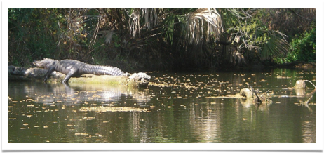 through. This wouldn’t have been a concern except for another gator, larger than the first, resting in the sun on the palm’s trunk. It turned its head to stare at us, while we stared back nervously. We blinked first. We decided we didn’t like the idea of possibly being stuck in the gap at the end of that very large, possibly man-eating gator’s perch. First back paddling, then turning around, we headed out the way we had come in.
Arriving back at Goode Park shortly after 1:00 PM, we decided to call it a trip. We pulled our boats out and set them in the grass at the top of the boat ramp, removed everything from our hatches, and reorganized our gear for the trip home. I called Lisa who was at the grocery store. She would be by to get us within the hour.
All-in-all this was a good trip, a self-supported adventure. And like any adventure, there were good parts, tedious parts, exciting and magnificent parts, and some parts to just get through. For me, the trip could have ended at IR-1. The uphill struggle to the desolate BC-38 and the disappointment of Turkey Creek sort of put a damper on the end of our trip. The Indian River County section of the Lagoon was much wilder than either the St. Lucie or Brevard County sections, with more birds and other animals to see. And IR-1 itself was a gem, a wildlife paradise of sorts. So, if I was looking for a pleasant three-day trip, I would start at the Fort Pierce Inlet in St. Lucie County again and paddle to IR-25A, then IR-1 and end at the Grant Fishermen’s Park, skipping the rest of Brevard County.
One postscript: Bruce continued to razz me about the “elusive manatee”. I had seen several, having almost run up on the back of one resting near the surface in the creek. Bruce jokingly accused me of making up stories. After Lisa arrived and we had loaded our boats and gear we noticed a commotion at the docks. Several people had gathered around a large manatee that was floating nearby, even letting people scratch its back. Thank God for small favors. Now I won’t have to listen to Bruce on that topic for the next few years!
DATA:
• Trip Odometer: 50.52 miles
• Paddled Today: 8.96 miles
• Maximum Speed: 4.0 MPH
• Time Moving: 3hr, 30 min.
• Moving Average: 2.6 MPH
• Time Stopped: 0hr, 47 min.
• Overall Average: 2.1 MPH
